 |
|||||||||||
 |
|||||||||||
|
|
|||||||||||
|
|||||||||||
|
|||||||||||
|
|
|||||||||||
|
||||||||||||||||||
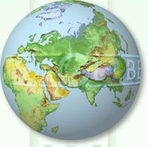
 Globe Rotation Globe RotationGeo-Globes comprises an impressive collection of 78 separate view points, 4 of the North Pole, 18 at latitude 40 degrees north, 18 equatorial, 18 at latitude 40 degrees south, 4 of the South Pole and an additional 16 images centred upon the countries of Europe. 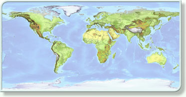 Each image is self contained with 6 colour variations and 8 channel masks comprising lakes, rivers and graticules etc., making it quick an easy to select the information you require. Click on the world image to view a Globe centred on an area of your choice. Globe Colours Each of the globes in this set has been designed with professional designers in mind embodying the highest cartographic standards. 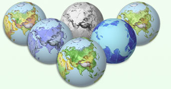 Once you have chosen your desired viewpoint, changing colours to one of the six standards is as simple as clicking the mouse. Once you have chosen your desired viewpoint, changing colours to one of the six standards is as simple as clicking the mouse.Unlike other products Geo-Globes are constructed digitally, and therefore are coloured accurately according to height and terrain type. Although these documents are RGB for use with on screen presentations all colours have been tabulated to correspond with reproducible CMYK colours. From start to finish this is a professional product created by professional cartographers. If however the colours provided are not suitable for the job required, the system allows you to quickly generate your own. 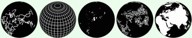 Topographic Masks Each Geo-Globe image comes complete with a series of topographic and feature masks, enabling the user to quickly add lakes, rivers, graticules and country boarders.
Digitally created drainage patterns for the whole world in fine detail. Lakes Lakes have been digitally created from the original DTM to give the most accurate outlines available at this scale. Graticules Graticules at every 10 degrees are another feature which may be added, above or below the landmasses as desired, and coloured or intensified to suit. Borders All the latest national and international borders are included Land Mask This mask enables the land to be separated from the ocean features. All these topographic features are independently constructed for each of the 78 viewpoints and may be manipulated in Photoshop prior to addition, i.e. colour, width, transparency etc. giving unlimited variability to suit individual needs. 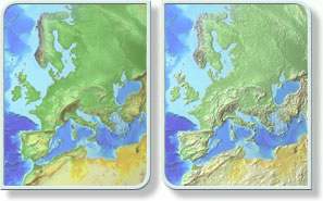 Special Effects Special EffectsOne of the amazing and unique features of Geo-Globes is the inclusion of the "Height Mask". This, used in conjunction with Adobe Photoshop's Lighting filter, allows the user to give extra 3d realism to the land or even create their own relief images from scratch. After satisfactorily creating the globe of your choice why not go one step further and add photographic lens flares, include the sun or even add clouds. Just one or two of the endless extensions you can make to Geo-Globes Technical Information Geo-Globes comprises a series of 19 individual elements including channel masks, layers and documents, designed to give hundreds of thousands of combinations, sufficient to satisfy even the most demanding design studio or publisher. And yet there is more. By manipulating the standard set in Adobe Photoshop the range of combinations runs into billions. Size / Scale Geo-Globes has been constructed for the professional user. At 300dpi, the 10.8" (27.6cm) high resolution images are at a scale of 1:46,000,000 When converted to 150dpi, the 21.6" (55.2cm) medium resolution images are at a scale of 1:23,000,000. And at screen resolution, 72dpi, the images are 45.26" (1.15metres) wide and at a scale of 1:11,000,000. Document contents Each Photoshop document contains 8 mask channels (Graticules, Lakes, Rivers, Boarders, Land, Globe and Shadow) as well as 7 Colour Layers (Land Colours 1, 2, 3, 4, 5(Greyscale), Ocean Relief and Blue Globe). Also included are three 'added effects' documents (1. Starry Night/Solar Flare, 2. Lens Flare, 3. Clouds). These documents include positional guides for adding your desired globe. Minimum requirements Adobe Photoshop 5.5 or above Minimum of 128Mb ram (512Mb + Recommended) Please note that Photoshop's Lighting Effects Filter requires physical memory and as such may not work with 128Mb ram Document sizes Each document is 40.6cm by 30.5cm (16x12 Inches). File sizes vary depending on land coverage (avg. 83Mb) Geo-Globes comes as a 2 DVD set (cd's available upon request) containing a massive 6.3 Gigabytes of information. Purchasing Information Geo-Globes ships as a 2 DVD set, containing a massive 6.3 Gigabytes of information This comprises 78 different view points covering the entire planet. (see technical information for further details). To celebrate the launch of the new Geo-Innovations website Geo-Globes is available for GB£275 including delivery (UK mainland and E.U. only) +VAT @ 17.5% Individual viewpoints may be purchased separately at GB£25 including delivery (UK mainland and E.U. only) . +VAT @ 17.5% for further information or to order contact: 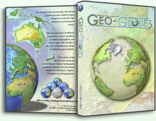 email: alan@geoinnovations.co.uk or write to: Geo-Innovations 14B Sea View Road Colwyn Bay Conwy North Wales UK LL29 8DG Telephone: +44 (0)1492 533384 Mobile: 0787 625 5601 |
||||||||||||||||||
 |
||||||||||||||||||
 |
||||||||||||||||||
 |
||||||||||||||||||
 |
||||||||||||||||||